Hier ein Bilder von Telegram. Ich war nicht immer mit Kamera unterwegs.


Hier ein Bilder von Telegram. Ich war nicht immer mit Kamera unterwegs.
Mittwoch 25.09.204 — Dies wird die erste Con auf deutschem Boden. Eurofurance lief parallel zum LGT Rave. Ich musste Prioritäten setzen. Die Anreise nach Rügen mache ich rückblickend aber nicht noch mal ohne weitere Punkte auf die Reiseliste zu setzen. 840 km sind einfach zu viel. Ich wusste das vorher und hatte auf dem Hinweg einen Zwischenstop auf der Höhe Hamburg eingeplant. Auch, weil ich bis 12 Uhr arbeiten muss, mein Wagen in die Werkstatt soll und ich den Mietwagen abholen muss.
Die Anreise war extrem nervig. Komplettes Verkehrschaos bei Köln und auf der A1 bis Kamener Kreuz. Der von mir gewählte Umweg war das dümmste, was mir einfallen konnte. Auf der A1 ging dann wegen Vollsperrung auch nichts. Also musste ich über A2/A7. Und das alles im strömenden Regen.In Hamburg kam dann noch eine Sperrung der A1-Elbbrücken dazu. Ich war erst kurz vor Mitternacht am Hotel.


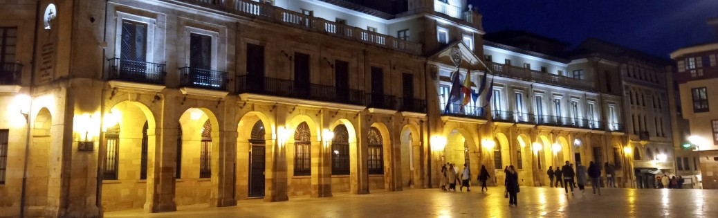
Donnerstag 26.09.2024 — Dafür war der nächste Tag und die restlichen 300 km entspannter. Ich war um 15 Uhr am Hotel in Prora. Der Hotelkomplex ist das alte „Kraft durch Freunde„-Projekt der NSDAP; geplant waren 20.000 Betten(!) Ich kann schon sehen wie das auf die Arbeiterschicht in den 1930ern gewirkt haben muss. Ehrlich, auch ich wäre auf die Propaganda reingefallen.
Mein Hotelzimer ist riesig; könnte sogar größer sein als meine Wohnung. Und … im Bad ist eine Saune. Wie genial ist das denn. Ich bin kurz am überlegen, ob ich das Wochenende nicht komplett im Hotel verbringe.
Für heute bleibt die Saune erst einmal kalt. Es ist Zeit für ConReg. Anders als bei großen Cons ist die Schlange zwei Leute lang. Und es ist auch nur eine Warteschlange, weil ich mich anstelle. Der Abend ist super entspannt. Ich hatte noch Wein und Käse gekauft. Allerdings habe ich vergessen, dass auf die offizielle Liste setzen zu lassen. Aber ich glaube die Idee hat Zukunft.


Freitag 27.09.2027 — Heute startet der Ausflug mit dem Rasenden Roland (Dampflokomotive) nach Putbus. Ich stehe um kurz vor 9 Uhr in Suit an der Bushaltestelle. Der Busfahrer ist verwirrt, aber zum Glück sind ein paar Con-Teilnehmer im Bus, die ein „Der gehört zu uns“ durch den Bus rufen.
Der Ausflug ist genial. Das Wetter ist kühl. Mich soll das nicht stören, denn theoretisch bin ich bis etwa 16 Uhr (7 Stunden) im Suit unterwegs; sicherlich zwischendurch „headless“. Ein Aperol Sprizz darf natürlich nicht fehlen; a gay drink for a gay Husky.
Der Ausflug war super. Allerdings hat uns der deutsche ÖPNV den Rückweg verhagelt. Ich habe keine Lust auf sowas und bestelle mir ein Taxi. Ich weiß wann meine Laune den Bach runter geht. Genau jetzt. Also muss ich raus aus der Situation. Entspannung finde ich in der Saune, dazu etwas Rotwein und Käse (Reste von gestern.)
Der Abend ist wenig spektakulär. Mich stört es nicht. Der Tag war aufregend genug und nach der Saune bin ich sowieso tiefenentspannt und mellow. Fehler war es, zu Fuß von meinem Hotel zum ConSpace zu laufen. Dieser Prora-Komplex ist riesig. Riesig. und dann ist da dieser Querriegel, um den man herum laufen muss.


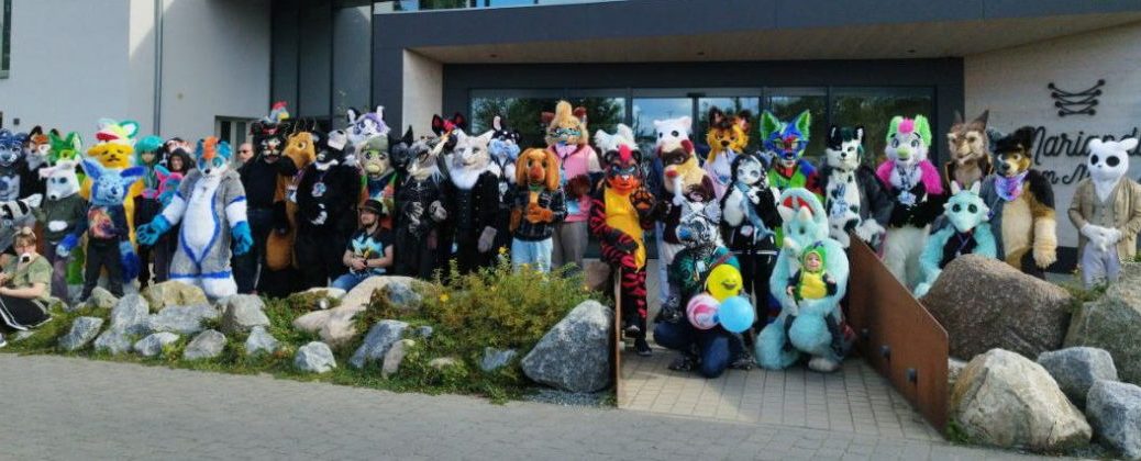
Samstag 28.09.2024 — Heute wird genauso entspannt wie gestern. Viel steht nicht auf dem ConZeitplan. Ich versuche mich, wenig erfolgreich, an einem Mix aus Fursuiting und Fotos machen. Ich muss diese Doppelrolle noch lernen.
Direkt neben dem ConSpace ist eine Sandskulturenaustellung. Sie ist nicht vergleichbar mit der Sandworld, die anfang der 2000er in Lübeck stattfand. Aber das waren auch andere Zeiten. Das kann und muss meine heute so sagen.


Sonntag 29.09.2024 — Heute ist schon wieder Abreise. 840 km. Wie gesagt, nächstes Mal mache ich das anders. Und ja, ich werde auch in Zukunft die RFC auf meiner Liste haben. Ich mag diese kleine Con mit nicht einmal 90 Teilnehmern.
Bevor es für 9 Stunden auf den Autobahn geht, mache ich noch ein paar Fotos in Binz. Um 16 Uhr starte ich dann endgültig auf den Rückweg. Mit einem Tankstopp auf der Höhe Dortmund ist diese Fahrt lang, langweilig und unspektakulär.


Heute endet Urlaub. Wir fahren Tanken und dann noch schnell für ein Frühstück/Mittagessen zum O Banquinho. Das ist eher ein Imbiss als ein Restaurant, aber es scheint beliebt zu sein. Der Laden ist rappelvoll.
Immer noch mit der Flasche Comanche-Wein im Gepäck geben wir den Mietwagen getankt zurück und lassen uns zum Flughafen fahren. Hier haben wir 2 Stunden Reserve vor dem Flug. Genug Zeit, das Verkehrschaos zu beobachten und den Wein zu trinken. Der passte nicht mehr in den Koffer, der randvoll mit Portwein ist.
Our vacation ends today. We fill up with gas and then quickly head to O Banquinho for breakfast/lunch. It’s more of a snack bar than a restaurant, but it seems to be popular. The place is packed.
Still with the bottle of Comanche wine in our luggage, we return the rental car with a full tank and get a ride to the airport. Here we have 2 hours to spare before the flight. Enough time to watch the traffic chaos and drink the wine. It no longer fits in the suitcase, which is full to the brim with port wine.


Das Verkehrschaos entfaltet sich vor der Halle des Flughafens, wo die Leute Ein- und Aussteigen. Wie an jedem Flughafen braucht man ein Ticket und nach 10 Minuten kostet es Parkgebühren. Nur scheinen immer wieder Leute, diese magische Marke zu reißen und stehen nun vor der Schranke und kommen nicht raus. Statt zur Seite zu fahren, steigen sie einfach aus und gegen zum Kassenautomat. Damit ist ein von zwei Schranken blockiert. Der Verkehr staut sich und weitere Leute reißen die 10-Minuten-Marke. Man ergänze nun protugisisches Temperament und die Show ist perfekt. Zumal das nicht einmal oder vereinzelt auftritt, sonder gefühlt alle 5 Minuten.
Die Show ist echt amüsant. Nachdem der Rosé alle ist, müssen wir jetzt noch den Rest vom Whisky vernichten. Den hatten wir in Heidelberg gekauft und hat wegen des Portweins ebenfalls keinen Platz mehr im Koffer. Alles in allem ist dieser Rückflug extrem gechillt.
Gegen 20:30 Uhr (30 Minuten verspätet) landen wir in Frankfurt. Unsere Koffer fallen gegen 21:15 Uhr auf das Gepäckband. Jetzt muss es schnell gehen. Wir hatten um 21 Uhr einen Tisch reserviertund die Küche schließt in wenigen Minuten. Mit dem Taxi statt dem Shuttle geht es zum Steigenberger Airport Hotel und direkt und mit Koffern in das Restaurant Unterschweinstiege.
The traffic chaos unfolds in front of the airport hall, where people are boarding and disembarking. As at any airport, you need a ticket and after 10 minutes you have to pay for parking. But people seem to keep breaking this magic marker and are now standing in front of the barrier and can’t get out. Instead of driving to the side, they simply get out and head for the ticket machine. This blocks one of the two barriers. Traffic builds up and more people break the 10-minute barrier. Now add protugisian temperament and the show is perfect. Especially as this doesn’t happen once or sporadically, but feels like every 5 minutes.
The show is really amusing. Now that the rosé has run out, we have to finish the rest of the whisky. We had bought it in Heidelberg and there was no more room in the suitcase because of the port wine. All in all, this return flight is extremely chilled.
We land in Frankfurt at around 8:30 pm (30 minutes late). Our suitcases fall onto the baggage carousel at around 9:15 pm. Now we have to be quick. We had reserved a table at 9 p.m. and the kitchen closes in a few minutes. We take a cab instead of the shuttle to the Steigenberger Airport Hotel and head straight to the Unterschweinstiege restaurant with our suitcases.


Die Hektik wird mit leckerem, deutschem Essen belohnt. Die Weinauswahl überlasse ich der Kellnerin. Sie empfiehlt einen Weißwein zum Wildbraten. Ich bin gespannt wie das harmoniert und werden nicht enttäuscht.
Wieder einmal checken wir erst kurz vor Mitternacht ein. Unser Zimmer ist im 7. Stock, aber die Nummer steht nicht auf dem Wegweiser im Flur. Ich habe so ein Gefühl und gehe einen der drei Korridore entlang bis zu der Tür auf der „Executive Tower“ steht. Dahinter finden wir einen Flur und weitere Zimmer, auch unseres.
Wir fallen ins Bett. Morgen bleibt nur noch der Weg zurück zum Flughafen. Toni fliegt zurück in die USA und ich versuche mich an der Deutschen Bahn. Leider.
The hectic pace is rewarded with delicious German food. I leave the choice of wine to the waitress. She recommends a white wine to go with the roast venison. I’m curious to see how it harmonizes and I’m not disappointed.
Once again, we check in just before midnight. Our room is on the 7th floor, but the number is not on the signpost in the hallway. I have a feeling and walk down one of the three corridors to the door that says “Executive Tower”. Behind it we find a corridor and more rooms, including ours.
We fall into bed. The only thing left to do tomorrow is get back to the airport. Toni flies back to the USA and I try the Deutsche Bahn. Unfortunately.
(translated with deepl.com)
Heute müssen wir zurück nach Porto. Morgen geht der Flieger nach Frankfurt. Wir verlassen Asturien aber nicht, ohne vorher Gijon an der Küste zu besuchen. Das war der ursprüngliche Ort unserer Hotelsuche.
Today we have to go back to Porto. Tomorrow the plane leaves for Frankfurt. But we won’t leave Asturias without visiting Gijon on the coast first. That was the original location of our hotel search.


Vor Gijon sind da außerdem noch ein paar Ruinen am Rand von Oviedo: San Miguel de Lillo und Santa María del Naranco aus dem 8. Jahrhundert. Die sind schnell abgehandelt. Eigentlich wollten wir dort wandern. Aber der Regen macht einen Strich durch diese Idee. Gestern hatten wir echt Glück mit dem Wetter. Ein Foto am „Lukenfiez“ Monumento al Sagrado Corazón de Jesús darf auch nicht fehlen.
Gijon ist bei weitem nicht zu schön wie Oviedo. Und die Preise sind spürbar höher. Ich vermute, das ist der Touristenaufschlag, den man auch in Orten an der Ostsee findet. Hauptattraktionen sind sicherlich die Iglesia de San Pedro direkt am Wasser, die Plaza Mayor de Gijon, die Ruinen der Batteria Alta de Santa Catalina sowie die Altstadt mit ihren Restaurant und Kniepen rund um die Plaza Periodista Artuso Arias. Die Basilica Santuario del Sagrado Corazon de Jesus hätten wir fast übersehen. Was ich nicht erwartet hatte war der riesige Jachthafen westlich der Halbinsel. Begleitet wird unser Rundgang übrigens von … wie sollte es anders sein … Regen.
Before Gijon, there are also a few ruins on the outskirts of Oviedo: San Miguel de Lillo and Santa Maria del Naranco from the 8th century. They are quickly dealt with. We actually wanted to go hiking there. But the rain put paid to that idea. We were really lucky with the weather yesterday. A photo at the ‘Lukenfiez’1 Monumento al Sagrado Corazón de Jesús is also a must.
Gijon is nowhere near as beautiful as Oviedo. And the prices are noticeably higher. I suppose that’s the tourist mark-up that you also find in places on the Baltic Sea. The main attractions are certainly the Iglesia de San Pedro right on the waterfront, the Plaza Mayor de Gijon, the ruins of the Batteria Alta de Santa Catalina and the old town with its restaurants and pubs around the Plaza Periodista Artuso Arias. We almost overlooked the Basilica Santuario del Sagrado Corazon de Jesus. What I hadn’t expected was the huge marina to the west of the peninsula. Incidentally, our tour was accompanied by … how could it be otherwise … rain.


Nach einem leckeren Tonkotsu Ramen in der Wabisabi Ramen Bar geht es auf die Autobahn. 6 Stunden fahrt liegen vor uns. Auf der A-66 geht es durch der Gebirge, dass die Küste von Zentralspanien trennt. ich erwarte, dass die Vegetation auf der anderen Seite anders sein wird. Und in der Tat sieht es südlich der Berge deutlich mehr nach Kalifornien aus: flache Büsche und auch die Farben deuten darauf hin, dass es hier im Sommer heiß und trocken wird. Die Küstenregien war komplett grün. Ich hatte gehofft, dass auch der Regen an den Bergen endet. Naja. Man kann nicht alles haben.
Ein Tankstop in Padornelo (hier parken gerade Sondertransporte mit riesigen Rotorblättern für Windkraftanlagen) erreichen wir die Grenze zwischen Spanien und Portugal. Ich bin extra von der Autobahn abgefahren und auch eine Nebenstraße, damit wir bei Feces de Abaixo ein paar Fotos von der „grünen Grenze“ machen können.
After a delicious Tonkotsu Ramen in the Wabisabi Ramen Bar, we hit the highway. We have 6 hours of driving ahead of us. The A-66 takes us through the mountains that separate the coast from central Spain. I expect the vegetation to be different on the other side. And indeed, south of the mountains it looks much more like California: flat bushes and the colors indicate that it gets hot and dry here in summer. The coastal regions were completely green. I had hoped that the rain would also end at the mountains. Oh well. You can’t have everything.
A refueling stop in Padornelo (special transports with huge rotor blades for wind turbines are parked here) we reach the border between Spain and Portugal. I took a detour off the highway and a side road so that we could take a few photos of the “green border” at Feces de Abaixo.


Erst weit nach Mitternacht erreichen wir das Airport Hotel, obwohl wir schon gegen 22 Uhr in Porto eintreffen. Aber wir stoppen zunächst am Koolhouse, da Toni dort seinen Reiseadapter vergessen hatte. Danach geht es zum Chinarestaurant, um unsere Regenschirme einzusammeln. Da es jetzt schon 22:50 Uhr ist, wird die Wahl fürs Dinner schwierig. In Portugal und Spanien sind Restaurants lange geöffnet, aber 23 Uhr ist auch hier langsam eng, zumal ich bei der bescheuerten Straßenführung an manchen Stellen die Abfahrt oder Abzweigung verpasse.
Wir warten auf 23:01 Uhr, damit auf google all die Restaurant verschwinden, die nur bis 23 Uhr geöffnet haben. Das Barril Antas ist mehr Kneipe als Restaurant hat aber laut google bis 2 Uhr geöffnet. Es gibt aber noch was zu Essen. Zwar sind es nur „Snacks“ aber die gehen bei mir als vollwertiges Abendesssen durch. Wir sind erst gegen 1 Uhr im Park Hotel Porto Aeroporto. Nicht so schlimm. Unser Flug ist gegen 16 Uhr, also konnen wir bis kurz vorm Checkout um 12 Uhr ausschlafen.
We don’t reach the airport hotel until well after midnight, although we arrive in Porto at around 10 pm. But we stop at the Koolhouse first, as Toni had forgotten his travel adapter there. Then we go to the Chinese restaurant to collect our umbrellas. As it is already 10:50 p.m., the choice for dinner is difficult. Restaurants are open late in Portugal and Spain, but 11 p.m. is getting a bit tight here too, especially as I miss the exit or turn-off in some places due to the stupid road layout.
We wait until 11:01 pm so that all the restaurants that are only open until 11 pm disappear on google. The Barril Antas is more of a pub than a restaurant, but according to google it’s open until 2am. But there is still something to eat. Although it’s only “snacks”, for me they pass for a full evening meal. We don’t get to the Park Hotel Porto Aeroporto until around 1am. Not too bad. Our flight is at 4pm, so we can sleep in until just before checkout at 12pm.
Ich bin gespannt was Oviedo zu bieten hat. Die historische Altstadt ist kompakt und sollte einfach innerhalb von einem Tag zu erwandern sein. Viel mehr Zeit haben wir auch nicht. Unter Hotel ist das Hotel & Spa Princesa Munia. Und wir haben ein paar Wellnesstermine gebucht.
Erster Stopps sind die Plaza del Fontán und Plazuela de Daoiz y Velarde. So habe ich mir eine historische spanische Altstadt vorgestellt. Auch nach einer Woche Urlaub bin ich noch immer von den farbenfrohen Fassaden begeistert.
I am curious to see what Oviedo has to offer. The historic old town is compact and should be easy to walk around in a day. We don’t have much more time anyway. Our hotel is the Hotel & Spa Princesa Munia. And we have booked a few wellness appointments.
Our first stops are the Plaza del Fontán and Plazuela de Daoiz y Velarde. This is what I imagined a historic Spanish old town to be like. Even after a week’s vacation, I am still amazed by the colorful facades.


In der C.Magdalena finden wir ein Hutgeschäft, in der ich eine Mütze wie in Peaky Blinders sehe und kaufe. Es ist eine Newsboy Cap, auch Newsboy Cap oder in Deutschland Ballonmütze genannt (siehe Foto). Ich wollte solch eine Mütze schon in den USA kaufen, habe es dann aber vergessen.
Nach der kurzen Shoppingtour erkunden wir weiter Oviedo, ohne Karte oder Plan. Wir finden auch so den Weg zur Catedral de San Salvador und dem Jardin de los Reyes Caudillos. Gleich dahinter liegt die C.Gascona von gestern Nacht. In der kleine Gasse dorthin entdecken wir einige kleine Kleipen. Mein Auge fällt auf die Bodega El Molinón.
In C. Magdalena we find a hat store where I see and buy a cap like the one in Peaky Blinders. It’s a newsboy cap, also called a newsboy cap or balloon cap in Germany (see photo). I wanted to buy such a cap in the USA, but then forgot about it.
After the short shopping tour, we continue to explore Oviedo without a map or plan. We find our way to the Catedral de San Salvador and the Jardin de los Reyes Caudillos. Just behind it is the C. Gascona from last night. In the small alleyway leading to it, we discover a few small Kleipen. My eye falls on the Bodega El Molinón.


Während Toni seines Wellnesstermin wahrnimmt, wandere ich alleine durch Oviedo, mache Fotos u.a. vom Teatro Compoamor, dem Junta General del Principado de Asturias, der Basilica de San Juan el Real, … Dann stehe ich wieder vorm El Molinón.
Es wird Zeit für ein Glas Wein. Bei der Gelegenheit frage ich, wo man die lokale Spezilität Fabada Asturiana essen kann. Die Antwort: „Hier“. Die Chance nutze ich und bestelle sofort. Fabada ist Eintopf mit weißen Bohnen, aber anders als in Deutschland mit viel Paprika. Und da El Molinón eine Auswahl von verschiedenen Wermuts hat, nutze ich auch diese Chance für ein Tasting, bevor ich von Toni „eingesammelt“ werde. Jetzt ist es Zeit für meinen Wellnesstermin.
While Toni attends his spa appointment, I wander through Oviedo on my own, taking photos of the Teatro Compoamor, the Junta General del Principado de Asturias, the Basilica de San Juan el Real, … Then I’m back in front of El Molinón.
It’s time for a glass of wine. I take the opportunity to ask where I can eat the local specialty, fabada asturiana. The answer: “Here”. I seize the opportunity and order immediately. Fabada is a stew with white beans, but unlike in Germany, with lots of paprika. And as El Molinón has a selection of different vermouths, I also take this opportunity for a tasting before I am “collected” by Toni. Now it’s time for my wellness appointment.


Gegen 9 Uhr starten wir die Suche nach einem Dinner. Wir finden das „La Mafia se sienta a la mesa„. Nachdem wir viel Glück mit dem La Famiglia in Lorsch hatten, warum nicht noch Mal bei der Mafia vorbeischauen. Im Anschluss geht es auf ein Cider zurück zu diesem kleinen Hole in Wall, dem El Ricón de Gascona.
At around 9 pm we start looking for a place to eat. We find “La Mafia se sienta a la mesa”. After our good luck with La Famiglia in Lorsch, why not stop by the Mafia again. Afterwards, we head back to this little hole in the wall, El Ricón de Gascona, for a cider.