Archiv der Kategorie: Off Topic

alles was nichts mit Japan zu tun hat, aber dennoch würdig ist, gepostet zu werden

USA 22 – Toronto, Canada

2023 war ich für ein Jahre in den USA. Jetzt ist es Trumpistan.
Bleibt fern. Besucht lieber Kanada und Mexiko. — And: Don’t buy American.

DEU

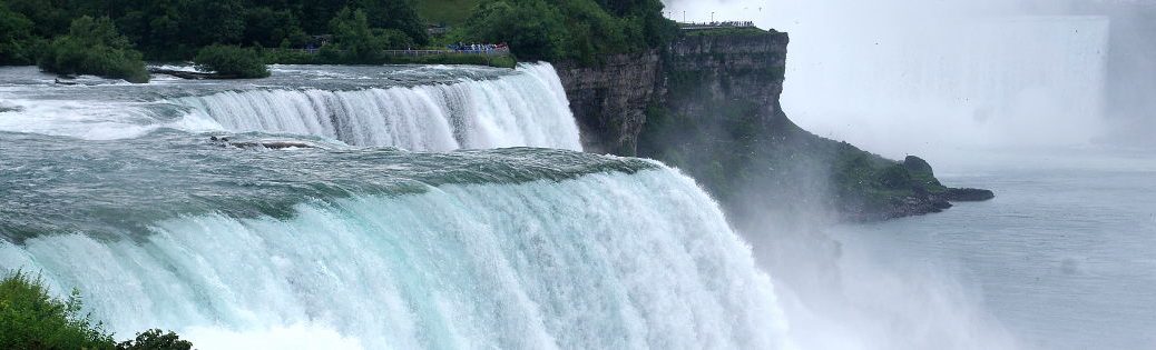
Heute geht es nach Toronto. Ein bekannter Drehort für viele US-Filme, da es billiger ist. Und Katsura Sunshine ist aus Toronto. Erster Stopp ist der Grenzübergang. Alles sehr einfach. Ich bin in Kanada; mal wieder. Die 420 bringt mich durch Niagara Falls (ja so heißt die Stadt) zum Queen Elizabeth Way. Es geht zur Küste des Lake Ontario und ihr entlang nach Hamilton, vorbei an Grimsby, von wo der Whisky von gestern stammt.

Hinter Hamilton geht es nach Osten, nur einen riesigen Stau vor vor mir zu haben. Ich wechsel auf den Lakeshore Road; keine Ahnung, ob das schneller ist. Die letzten Meilen folge ich dem Gardiner Expressway und suche mir ein Parkhaus am Harbour Square. Mal sehen, ob ich das heute Abend so einfach wiederfinde.

Einen konkreten Plan habe ich nicht. Ich laufe einfach drauf los. Zuerst geht es in das Stadtzentrum. Erster Stopp ist der CRAFT Beer Market Toronto. Lieber jetzt ein Bier und dann nüchtern auf der Rückfahrt. Die Auswahl ist riesig. Und die Bar hat 40+ Zapfhähne.

Von hier aus ist es ein Katzensprung zum alten Rathaus (erinnert mich an die Niederlande), dem Nathan Phillips Square mit dem Toronto-Zeichen und dem neuen Rathaus, das sogar bei Star Trek vorkommt.

Ich laufe weiter zum Queen’s Park. Hier ist die Universität von Toronto mit ihren Fakultäten. Ich gönne mir einen kleinen Umweg über Mc Caul Street. Ich wollte ein Foto von der Art Gallery of Ontario machen. Eine Regenwolke zwingt zur kurzen Planänderung. Der Village Idiot Pub1 lädt ein. Und wie geil ist das denn. Die haben Becks !!! Dazu Lammcurry und das Mittagessen ist gesichert. Die Bierkarte ist erstaunlich. Ich finde alle belgischen Biere, die aus Deutschland kenne, dazu viele deutsche und englische Marken. Auch die Bar die Straße runter hat Werbung für Stiegl, Weihenstephan und Co.

An der Bllor Street angekommen gehe ich nach Osten bis Parliament Street. Es geht zurück nach Süden. Die Gegend heißt Cabbagetown. Die Läden wirken sehr Englisch mit ihren knallbunten Fassaden aus Holz. Es ist nicht die Beste Gegend.

Es geht zurück nach Old Toronto. St. James Cathedral ist der nächste Stopp auf meiner Liste. Nur ein paar Meter entfernt folgen das Gooderham Building und die Hockey Hall of Fame. Zurück an der York Street ist die Rundreise komplett. Nächster Stopp ist der CN Tower. Es ist der höchste Turm der westlichen Hemisphäre (555m).2 Sehr geschickte Wortwahl, da es etliche höhere Funktürme in Asian gibt, aber damit in der östlichen Hemisphäre. Ich fahre hinauf.

Die Sicht ist eingeschränkt, trotz der Höhe von 342 (damit ist die Aussichtplattform nur ein wenig unterhalb der ersten Ebene des Tokyo Sky Tree). Ein paar hundert Kilometer von hier sind riesige Waldbrände. Der Rauch hat vor ein paar Tagen sogar New York in Nebel gehüllt. Ich fahre sogar rauf zum Sky Pod auf 447m. Er kommt damit auf die gleiche Höhe wie die zweite Ebene des Sky Tree.

Ich muss kurz innehalten. Das Ding kommt auf die gleichen Aussichtshöhen wie der Sky Tree. Das habe ich dem Turm nicht zugetraut. Aber wenn ich nach unten schaue, kommt das hin. Unter uns ist übrigens das Baseball Stadion, wo gerade ein Spiel läuft. Ich muss noch mal bei gutem Wetter wiederkommen. Man soll die Gischt der Niagarafälle von hier oben sehen können.

Jetzt geht es zurück zum Auto. Abendessen organisiere ich mir hier in Toronto, denn zurück in den USA wird es zu spät sein. Katsura Sunshine hat mir empfohlen nach Greektown zu fahren. Auf gehts. Danforth Avenue ist programmiert. Aber ich lande im falschen Abschnitt der sehr langen Straße. Blöd gelaufen. Ich bin in der afrikanischen Ecke gelandet. Ich wähle ein Äthiopisches Restaurant. Das war vermutlich eine bessere Wahl. Ich habe nie zuvor afrikansiche Küche probiert. Es ist lecker. Nur, dass es kein Geschirr gibt und man mit den Fingern isst, irritiert.

Kurz vor 22 Uhr bin ich zurück am Wagen. Vor mir liegen 2 Stunden Fahrzeit zurück in die USA. Die Fahrt ist ereignislos. Der Grenzbeamte ist sichtlich gelangweilt. Klar es ist bereits Mitternacht. 500m hinter der Grenze bin ich zurück am Hotel. Es folgt ein Abschlussdrink und dann geht es ins Bett. Heute waren es 180 Meilen mit den Auto. Morgen folgen dann 440 Meilen (über Cleveland nach Pittsburgh).

ENG

Today we’re heading to Toronto. It’s a well-known filming location for many US movies because it’s cheaper. And Katsura Sunshine is from Toronto. Our first stop is the border crossing. Everything is very simple. I’m in Canada; once again. The 420 takes me through Niagara Falls (yes, that’s the name of the city) to Queen Elizabeth Way. We head to the coast of Lake Ontario and drive along it to Hamilton, past Grimsby, where yesterday’s whisky came from.

After Hamilton, I head east, with only a huge traffic jam ahead of me. I switch to Lakeshore Road; no idea if it’s faster. For the last few miles, I follow the Gardiner Expressway and look for a parking garage at Harbour Square. Let’s see if I can find it again so easily tonight.

I don’t have a specific plan. I’ll just start walking. First, I’ll head to the city center. My first stop is the CRAFT Beer Market Toronto. I’d rather have a beer now and then be sober on the way back. The selection is huge. And the bar has over 40 taps.

From here, it’s a stone’s throw to the Old City Hall (reminds me of the Netherlands), Nathan Phillips Square with the Toronto sign, and the New City Hall, which even appears in Star Trek

I continue walking to Queen’s Park. This is where the University of Toronto and its faculties are located. I treat myself to a little detour via Mc Caul Street. I wanted to take a photo of the Art Gallery of Ontario. A rain cloud forces me to change my plans. The Village Idiot Pub3 looks inviting. And how cool is that? They have Becks!!! Add lamb curry and lunch is sorted. The beer menu is amazing. I find all the Belgian beers I know from Germany, plus many German and English brands. The bar down the street also advertises Stiegl, Weihenstephan, and Co.

Once I reach Bllor Street, I head east to Parliament Street. Then I turn south. The area is called Cabbagetown. The shops look very English with their brightly colored wooden facades. It’s not the best neighborhood.

I head back to Old Toronto. St. James Cathedral is the next stop on my list. Just a few meters away are the Gooderham Building and the Hockey Hall of Fame. Back on York Street, the tour is complete. The next stop is the CN Tower. It is the tallest tower in the Western Hemisphere (555 m). 4 Very clever choice of words, as there are several taller radio towers in Asia, but that’s in the Eastern Hemisphere. I go up.

The view is limited, despite the height of 342 meters (which means the observation deck is only slightly below the first level of the Tokyo Sky Tree). A few hundred kilometers from here, there are huge forest fires. A few days ago, the smoke even enveloped New York in fog. I even go up to the Sky Pod at 447 meters. This puts it at the same height as the second level of the Sky Tree.

I have to pause for a moment. This thing is at the same viewing height as the Sky Tree. I didn’t think the tower was capable of that. But when I look down, it makes sense. By the way, below us is the baseball stadium, where a game is currently being played. I have to come back when the weather is good. You’re supposed to be able to see the spray from Niagara Falls from up here.

Now it’s back to the car. I’ll organize dinner here in Toronto, because it will be too late back in the US. Katsura Sunshine recommended that I go to Greektown. Let’s go. Danforth Avenue is programmed. But I end up in the wrong section of the very long street. Bad luck. I ended up in the African corner. I choose an Ethiopian restaurant. That was probably a better choice. I’ve never tried African cuisine before. It’s delicious. The only thing that’s irritating is that there are no plates and you have to eat with your fingers.

Shortly before 10 p.m., I’m back at the car. I have a 2-hour drive back to the US ahead of me. The drive is uneventful. The border guard is visibly bored. Of course, it’s already midnight. 500 meters past the border, I’m back at the hotel. I have a nightcap and then go to bed. Today I drove 180 miles. Tomorrow I’ll drive 440 miles (via Cleveland to Pittsburgh).


USA 21.2 – Niagara Falls CAN

2023 war ich für ein Jahre in den USA. Jetzt ist es Trumpistan.
Bleibt fern. Besucht lieber Kanada und Mexiko. — And: Don’t buy American.

DEU

Ich habe einen Reisepass und ein VIP-Visum, da ich ja beruflich in den USA bin. Ein Abstecher nach Kanada ist für mich so einfach sein, wie für einen Kaffee nach Paris zu fahren. Ich gehe durch das Drehkreuz und passiere die Rainbow international Bridge.  Vor mir ist Kanada.

Ein paar Fragen der Border Patrol später bin ich in Kanada. Wow. Wenn ich das überlege: Einfach so, zu Fuß, nach Kanada. Nur leider hat es die Kameraoptik zerlegt: der Sprühnebel der Fälle, die Gewitterfront und die Klimaanlage im Hotel. Mein Weitwinkel ist komplett beschlagen; zwischen den Linsengruppen, wo ich nicht rankomme. Bei der aktuellen Luftfeuchtigkeit kann das Stunden dauern. Dieses Objektiv ist ein Totalausfall.

Ich werde nicht die besten Bilder mit nach Hause nehmen. Stattdessen sauge ich hier alles persönlich auf. Der Blick von der kanadischen Seite auf die American Falls und die Horseshoe Falls ist um Längen besser als von der US-Seite.

Ich stoppe für ein Bier im Queen Victoria Place Restaurant. Meine Wahl fällt auf das Barking Squirrel, einzig wegen das Namen. Dazu noch einen kanadischen Whisky: Forty Creek, hier aus Ontario, nur ein paar Kilometer entfernt.

Kandanisches Geld ist erfrischend bunt nach all dem grünen Kram in den USA. Daran dass es aus Plastik ist, muss man sich gewöhnen. Der Wechselkurs ist etwas verwirrend (US$ zu Euro ist grob 1:1). Ich weiß nicht wirklich, was das Bier gekostet hat. Es ist aber billiger als die USA, soweit kann ich das sagen.

Das Bier war auch durch eine weitere Regenfront motiviert, die hier gerade durchzieht. Nach dem Regen ist vor dem Sonnenuntergang.  Die Sonne steht tief und wann hat man scon mal Niagara-Fälle (beide Teile) und einen Regenbogen. Der kleine Regenbogen durch die Gischt ist normal, aber das volle Programm? Ich habe echt Glück … und ein immer noch beschlagenes Objektiv. Arghhh.

Rechts am Ufer sehe ich das alte  Wasserkraftwerk. Irgendwo davor liegt das Wrack einer Schute im Wasser. Ich finde das Ding nicht. [Nachtrag: Ich habe es aber durch Zufall mit auf einem der Fotos.] Im Hintergrund ist der International Control Damn zu sehen. Mit ihm kann man die Horseshoe Falls auf die Hälfte drosseln. Das passiert nachts und dient der Stromgewinnung. (Das Thema Wasserkraftwerke an den Niagarafällen ist spannend. Das werde ich irgendwann einmal nachreichen.)

Doppelte Einreise

Kurz vor Sonnenuntergang geht es zurück in die USA. Was man wissen sollte: Der Weg zurück kostet $1 US oder $1 CAN. In bar. Ich wühle meine Taschen durch. Glück gehabt. Ich habe tatsächlich etwas Bargeld dabei.

Die Wiedereinreise in die USA ist denkbar einfach. Der Officer schaut kurz auf meine Visum. „Oha. NATO“. 30 Sekunden später bin ich wieder in den USA. Jetzt muss ich … WO IST MEIN SMARTPHONE?

Da mein gesamtes US-Leben an das Smartphone bzw. die Telefonnummer geknüpft ist, werde ich nervös. In Deutschland wäre es mir scheißegal, aber hier in den USA klebt das ganze Leben, selbst der Zugang zum Dienstrechner, an diesem Scheißding. Und ich habe es in Kanada verloren/vergessen.

Ich frage den Grenz-Officer auf der USA-Seite.Vielleicht habe ich es bei der Einreise … Nein.  Letzte Hoffnung ist, dass ich es auf der Suche nach Bargeld in Kanada habe liegen lassen.

Es geht im Eiltempo zurück nach Kanada. Der kanadische Officer ist etwas vorwirrt über meinen Einreisegrund: Handy suchen. Ich umkreise seinen Schreibtisch und stehen 10 Sekunden später schon wieder auf der Ausreiseseite. Ich habe so ein Glück. Das Smartphone liegt wirklich noch oben auf dem Zahlautomaten.

Erneut geht es zurück in die USA. Zurück zum gleichen Officer. Ich bin mir sicher; der Titel „Crazy tourist of the week“ gehört mir. Er will mich so durchwinken, aber ich muss zurück ins System. Kein Risiko mit meinen I-94-Dokument.

Bleibt die Frage nach dem Abendessen. Ich frage das Hotelpersonal. Die empfehlen mit das Wine in Third. 3rd Street ist nicht wirklich hübsch. Umsomehr überrascht mich das Restaurant. Es ist immer noch sehr amerikanisch, aber sie haben brauchbaren Wein auf der Karte. Und auch sonst ist es irgendwie anders. Mag an der Nähe zu Kanada liegen. Ich investiere in das Steak Parmesan, medium well. Steak funktioniert immer in den USA.

Damit endet das Abendteuer Niagarafälle. Morgen geht es nach Toronto und dann auch schon nach Pittsburgh.

ENG

I have a passport and a VIP visa, as I am in the US on business. A trip to Canada is as easy for me as going to Paris for a coffee. I walk through the turnstile and cross the Rainbow International Bridge. Canada lies before me.

A few questions from the Border Patrol later, and I’m in Canada. Wow. When I think about it: just like that, on foot, to Canada. Unfortunately, the camera lens has broken: the spray from the falls, the storm front, and the air conditioning in the hotel. My wide-angle lens is completely fogged up; between the lens groups, where I can’t reach it. With the current humidity, it could take hours. This lens is a total failure.

I won’t be taking the best pictures home with me. Instead, I’m soaking everything up personally. The view of the American Falls and Horseshoe Falls from the Canadian side is far better than from the US side.

I stop for a beer at the Queen Victoria Place Restaurant. I choose the Barking Squirrel, solely because of the name. I also order a Canadian whiskey: Forty Creek, from Ontario, just a few kilometers away.

Kandan money is refreshingly colorful after all the green stuff in the US. You have to get used to the fact that it’s made of plastic. The exchange rate is a bit confusing (US$ to Euro is roughly 1:1). I don’t really know how much the beer cost. But it’s cheaper than in the US, as far as I can tell.

The beer was also motivated by another rain front that is currently passing through here. After the rain comes the sunset. The sun is low, and when do you ever get Niagara Falls (both parts) and a rainbow? The small rainbow through the spray is normal, but the full program? I’m really lucky… and still have a fogged-up lens. Arghhh.

On the right bank, I see the old hydroelectric power station. Somewhere in front of it lies the wreck of a barge in the water. I can’t find the thing. [Addendum: But I happened to capture it in one of the photos.] The International Control Dam can be seen in the background. It can be used to reduce the flow of Horseshoe Falls by half. This happens at night and serves to generate electricity. (The topic of hydroelectric power plants at Niagara Falls is fascinating. I’ll get back to that sometime.)

Double entry

Shortly before sunset, it’s time to head back to the US. What you need to know: The return trip costs $1 US or $1 CAN. In cash. I rummage through my pockets. Lucky me. I actually have some cash on me.

Re-entering the US is very easy. The officer takes a quick look at my visa. “Oh, NATO.” Thirty seconds later, I’m back in the US. Now I have to… WHERE IS MY SMARTPHONE?

Since my entire life in the US is tied to my smartphone and phone number, I’m getting nervous. In Germany, I wouldn’t give a damn, but here in the US, my whole life, even access to my work computer, is tied to this damn thing. And I lost/forgot it in Canada.

I ask the border officer on the US side. Maybe I lost it when I entered the country… No. My last hope is that I left it behind in Canada while looking for cash.

I rush back to Canada. The Canadian officer is a little confused about my reason for entering the country: to look for my cell phone. I circle his desk and 10 seconds later I’m back on the exit side. I’m so lucky. The smartphone is really still on top of the payment machine.

Once again, I’m back in the US. Back to the same officer. I’m sure I’ve earned the title of “Crazy tourist of the week.” He wants to wave me through, but I have to go back into the system. No risk with my I-94 document.

The question of dinner remains. I ask the hotel staff. They recommend Wine in Third. 3rd Street isn’t really pretty. The restaurant surprises me all the more. It’s still very American, but they have decent wine on the menu. And it’s somehow different in other ways too. Maybe it’s because it’s close to Canada. I invest in the steak parmesan, medium well. Steak always works in the USA.

This concludes the Niagara Falls adventure. Tomorrow we’re off to Toronto and then on to Pittsburgh.

USA 21.1 – Niagara Falls USA

2023 war ich für ein Jahre in den USA. Jetzt ist es Trumpistan.
Bleibt fern. Besucht lieber Kanada und Mexiko. — And: Don’t buy American.

DEU

Meine Anfahrt erfolgt über den Niagara Scenic Parkway. Links ist der Niagara River5. Auf anderen Seite ist Kanada. Ich kann noch nicht ganz glauben, dass der Fluss nur ein paar Kilometermetern entfernt über die Niagarafälle 57 m in die Tiefe stürzt. Ich muss kurz realisieren, was ich hier mache: Ich bin in den USA. Das da drüben ist Kanada. Vor mir sind die Niagarafälle. Alles kenne ich nur aus Film und Fernsehen.

Ach ja, ich bin zurück in New York. Es klingt verwirrend aber Buffalo und die US-Seite der Niagara Falls sind im US-Bundesstaat New York.

Ich parke den Wagen am Fluss etwa 500m vor den Fällen. Der Niagara River teilt sich hier. Die meisten Wassermassen fließen westlich von Goat Island über den berühmten Horseshoe Falls. Ein kleinerer Teil geht nordöstlich der Insel über die Americal Falls. Und obwohl dies hier der Nebenarm ist, die Strömung ist der Wahnsinn. Ja, jetzt sieht man der Strömung, dass gleich was passieren wird. Kein Vergleich zu den ruhigen Bildern ein paar hundert Meter zuvor. Und es sind noch etwa 600 m bis zu den Fällen.

American Falls

Ich laufe am Park entlang (Google markiert hier American Rapids Viewing Area). Ja, kommt hin. Ein Brücke führt rüber auf Green Island. Die Gewässer rechts heißen Hells Half Acre. Ziemlich passen. Wer hier ins Wasser fällt, hat keine Chance auf Rettung.

Ich wandere langsam rüber zu Goat Island und zu den American Falls. Es gibt eine Aussichtsplattform auf der kleinen Luna Island, die mitten in Hells Half Acre liegt. Auf der einen Seite sind die American Falls, auf der anderen Seite die schmalen Bridal Veil Falls.6

Wow. Impressive. Und das hier sind die kleinen Wasserfälle. Hier auf der insel gibt es die Cave of the Winds. Es ist ein Bereich unterhalb der Fälle, wo die Wassermassen nach ihrem Sturz in die Tiefe aufschlagen. Für Fotos nicht der beste Ort; für die Kamera weniger. Es ist eine Menge Gischt in der Luft.

Ich kann es kaum erwarten, die Horseshoe Falls in Angriff zu nehmen. Aber zuvor kommt Regen. Eine Gewitterfront zieht auf. Ich befinde mich natürlich am blödesten Ort: weiter weg vom Auto kann ich nicht sein. Den Terrapin Point mit Blick auf die Horseshoe Falls lasse ich ausfallen. Ich habe keine Chance, trocken zu bleiben, trotzdem eile ich zurück zum Auto. Der Regen wird nach Internet  mindestens eine Stunde dauern. Da kann ich in der Zeit auch im Hotel einchecken.

Das Zimmer ist OK. Der Name Sheraton verspricht mehr, aber egal. Es war günstig. Der Parkplatz liegt direkt an der Niagara St, die zum Grenzübergang nach Kanada führt. Als Basiscamp optimal.

Nach einer kurzen Pause Hotel geht es zurück zu den American Falls, genauer gesagt dem American Falls Tower. Ein Aussichtsturm. Hier führt auch ein Fahrstuhl hinab zu den Ausflugsbooten. Und trotz des Regenschauers ist hier eine riesige Warteschlange. Auf sowas habe ich nun wirklich keine Lust.

Auf nach Kanada …

Nachtrag vom 28.06.2023

Heute geht es über Cleveland nach Pittsburgh. Trotzdem. Ein paar Fotos von den Falls brauche ich noch. Und zurück am Tower sehe ich keine Warteschlage für die Bootsfahrt. Diese Chance muss ich nutzen!

Rauf aufs Boot und los. Natürlich ist die Kamera nach der halben Tour hilflos. Das Objektiv ist nass, Wassertropfen auf der Linse. ich wechsel also wieder auf „Genießen ohne Beiwese“. Wir passieren die American Falls. Je näher wir den Horseshoe Falls kommen desto lauter wird, desto imposanter wird es. Die Hälfte der Fälle ist hinter der Gischt versteckt.

Das Boot fährt in die Mitte des Halbkreises. Das Ticket hat sich gelohnt. Fast komplett rund herum um das Boot, in einer Entfernung von etwa 100m, stürzen Wassermassen 57m in die Tiefe, grob 2,5 Millionen Liter pro Sekunde! Theoretisch bin ich wieder in Kanada.

Plastikverbrauch: Jeder Tourist bekommt einen Poncho aus Plastik. Das ist nicht verkehrt, da es sehr nass werden wird. Wenn ich jetzt aber hochrechne wie viele Touristen hier am Tag durchgeschleust werden und einen Poncho für 30 Minuten anziehen und danach wegwerfen …

ENG

I take the Niagara Scenic Parkway to get there. On the left is the Niagara River7. On the other side is Canada. I still can’t quite believe that just a few kilometers away, the river plunges 57 meters over Niagara Falls. I have to take a moment to realize what I’m doing here: I’m in the US. Over there is Canada. In front of me are Niagara Falls. I only know all of this from movies and television.

Oh yes, I’m back in New York. It sounds confusing, but Buffalo and the US side of Niagara Falls are in the US state of New York.

I park the car by the river about 500 meters before the falls. The Niagara River splits here. Most of the water flows west of Goat Island over the famous Horseshoe Falls. A smaller portion flows northeast of the island over the American Falls. And even though this is the tributary, the current is insane. Yes, now you can see from the current that something is about to happen. No comparison to the calm images a few hundred meters earlier. And it’s still about 600 meters to the falls.

American Falls

I walk along the park (Google marks this as American Rapids Viewing Area). Yes, that’s about right. A bridge leads over to Green Island. The waters on the right are called Hells Half Acre. Quite fitting. Anyone who falls into the water here has no chance of rescue.

I slowly walk over to Goat Island and the American Falls. There is a viewing platform on the small Luna Island, which lies in the middle of Hells Half Acre. On one side are the American Falls, on the other side the narrow Bridal Veil Falls. 8

Wow. Impressive. And these are the small waterfalls. Here on the island is the Cave of the Winds. It is an area below the falls where the water hits the ground after its descent. Not the best place for photos; not so good for the camera. There is a lot of spray in the air.

I can’t wait to tackle Horseshoe Falls. But first, rain. A thunderstorm front is approaching. Of course, I’m in the worst possible place: I couldn’t be further away from the car. I skip Terrapin Point with its view of Horseshoe Falls. I have no chance of staying dry, but I hurry back to the car anyway. According to the internet, the rain will last at least an hour. I might as well check into the hotel in the meantime.

The room is OK. The Sheraton name promises more, but never mind. It was cheap. The parking lot is located directly on Niagara Street, which leads to the border crossing into Canada. Ideal as a base camp.

After a short break at the hotel, we head back to the American Falls, or more precisely, the American Falls Tower. It’s an observation tower. There’s also an elevator that takes you down to the excursion boats. And despite the rain shower, there’s a huge line here. I really don’t feel like waiting in line.

Off to Canada…

Addendum dated 28 June 2023

Today we’re heading to Pittsburgh via Cleveland. Still, I need a few photos of the falls. And back at the tower, I don’t see any queue for the boat trip. I have to seize this opportunity!

I hop on the boat and off we go. Of course, halfway through the tour, my camera is useless. The lens is wet, with water droplets on it. So I switch back to “enjoying without evidence.” We pass the American Falls. The closer we get to the Horseshoe Falls, the louder and more impressive it becomes. Half of the falls are hidden behind the spray.

The boat sails into the middle of the semicircle. The ticket was worth it. Almost completely around the boat, at a distance of about 100 meters, masses of water plunge 57 meters into the depths, roughly 2.5 million liters per second! Theoretically, I am back in Canada.

Plastic consumption: Every tourist gets a plastic poncho. That’s not a bad idea, as it’s going to get very wet. But if I extrapolate how many tourists pass through here every day, wear a poncho for 30 minutes and then throw it away…


USA 20 – CSD San Francisco

2023 war ich für ein Jahre in den USA. Jetzt ist es Trumpistan.
Bleibt fern. Besucht lieber Kanada und Mexiko. — And: Don’t buy American.

DEU

Samstag, 24.06.2023 —  Ich bin erst am Montag aus LA zurück gekommen. Gerade genug Zeit, um die Waschmaschine zu füttern und die Koffer neu zu packen. Denn heute geht es schon wieder weiter. ANTHROCON9 steht vor der Tür. Die große Furry-Convetion in Pittsburgh, PA. Damit sich der Flug lohnt, habe ich noch einen Trip zu den Niagarafällen in die Reiseroute eingebaut. Und damit nicht genug. Morgen ist die Pride Parade in San Francisco.

Und so sitze ich früh morgens erneut in einem Mietwagen. Ich bin mittlerweile Stammgast bei AVIS am Flughafen. Sie erklären mir schon gar nichts mehr, sondern geben mir gleich die Schlüssel.

Ich parke gegenüber vom BEI-Hotel. Es ist schon ein Vorteil, wenn man die Gegend und den Standort der Parkhäuser kennt. Von hier geht es zum Civic Center Park. Die Straßen nordöstlich sind als Veranstaltungsgelänge abgeriegelt. Nicht nur gesperrt. Abgeriegelt mit Panzersperren und quer gestellten LKWs.

Viel zu berichten gibt es nicht. Die Veranstaltung ist bunt, laut10 und queer; genau nach meinem Geschmack.

Zu berichten gibt es nicht viel. Ich genieße die Party.  Ich treffe sogar ein paar Furries. Warum habe ich nicht daran gedacht? Gyoji liegt gut verpackt im Auto. Egal.

Am späten Nachmittag verlege ich in Richtung Castro. Parken ist gar nicht so einfach. Ich finde etwas in der 26th Street. Das ist nicht nur am Arsch der Welt, sondern ganz weit den Berg hinauf (80 Höhenmeter).

Von hier laufe ich erst zum Mission Dolores Park. Von hier hat man einen guten Blick auf dem Skyline von San Francisco. Leider haben die Amerikaner eine Menge Müll hinterlassen. Es ist nicht so schlimm wie beim Indy500, aber trotzdem. Ich vermisse Japan. Dort findet man nach einer Party maximal umgeknickte Grashalme.

Sonntag, 25.06.2023 — Heute ist Prideparade. Aber erst muss ich den Wagen abgeben. Ich hatte ihn nur für 24 Stunden gebucht. Getankt hatte ich gestern noch. S Airport Blvd und dann bin ich auch schon da. Die Rückgabe ist einfach. Das funktioniert einfach in den USA. Ich laufe zurück zum Hotel. Dumme Idee. Es sind 2 Meilen entlang einer linealgeraden US-Straße. Ich froh, dass es zumindest Gehwege gibt.

Zurück am Hotel checke ich aus, parke mein Gepäck an der Rezeption und bestelle ein uber zurück in die Innenstadt. Das kostet knapp $30 pro Richtung ist aber billiger als ein Parkplatz und ein weiterer Tag Fahrzeugmiete.

Der Fahrer setzt mich in der Nähe vom SF Eagle ab. Für die Parade sind etliche Straßen gesperrt, u.a. Market Street. Das Verkehrschaos ist entsprechend.

Die Parade ist hinter Bauzäunen. Anders als in Deutschland gibt es keine Chance Teil der Parade zu werden. Ich bin mir nicht sicher, ob das Schutz gegen Terror ist, oder ob sie die Anzahl der teilnehmenden Schwulen und Lesben begrenzen wollen. In den USA halte ich beides für denkbar. Das Veranstaltungsareal ist rund um den Civic Center Park. Keine Ahnung wo die Obdachlosen jetzt sind. Aber lassen wir das USA-Bashing. Man soll nicht auf Leute eintreten, die schon am Boden liegen.

Nach der Parade besuche ich noch kurz das SF Eagle und mache einen erneuten Abstecher nach Castro. Viel zu berichten gibt es nicht. Bereits im 19:30 bringt mich eun uber zurück zum Hotel. Von hier geht es mit Koffern zum Flughafen. Der Flug ist kurz vor Mitternacht.

Montag 26.07.2025 — Wir landen früh morgens in Chicago. Hier muss ich in den Flieger nach Buffalo wechseln. Den Flughafen kenne ich schon. Das macht es einfacher, mich zu orientieren. Ich finde einen Platz, der eigentlich noch gar nicht geöffnet hat. ich bekomme trotzdem ein Bier und ich kann sogar etwas zu Essen ordern. Die Bedienung hat einen direkten Draht zu einem anderen Lokal.

Der Flug nach Buffalo ist kurz und kreuzt eine weitere Zeitzone. Immer noch am Morgen stehe ich an der Mietwagen-Abholstation. Und erneut bin ich verblüfft, wie dumm Amerikaner sein können: Einer will einen Wagen ohne Kreditkarte (als Sicherheit für Diebstahl und Schäden) anmieten. Der andere hat keinen Führerschein. Er hat also nicht nur keine Fahrerlaubnis sondern auch keine Ausweispapiere. Ich ich stehe hinter diesen Evolutionssackgassen in der Warteschlange.

Endlich habe ich die Schlüssel. Und ja, ich treffe auf Amerikaner, die an der Anweisung „Gang entlang, rechts die Fahrstühle runter zur Ebene B2, dort nach links gehen“ scheitern. Keine Witz. Und eigentlich einfach, zumal es ausgeschildert ist. Egal. Auf die I-90, direkt auf die I-290 und dann auf die 62.

ENG

Saturday, 24.06.2023 —  I just got back from LA on Monday. Just enough time to feed the washing machine and repack my suitcases. Because today I’m off again. ANTHROCON11 is just around the corner. The big furry convention in Pittsburgh, PA. To make the flight worthwhile, I’ve added a trip to Niagara Falls to the itinerary. And that’s not all. Tomorrow is the Pride Parade in San Francisco.

And so, early in the morning, I find myself sitting in a rental car once again. I’m now a regular at AVIS at the airport. They don’t even bother explaining anything to me anymore, they just hand me the keys.

I park across from the BEI Hotel. It’s definitely an advantage to know the area and the location of the parking garages. From here, I head to Civic Center Park. The streets to the northeast are cordoned off as an event venue. Not just closed off. Cordoned off with tank barriers and trucks parked across the streets.

There’s not much to report. The event is colorful, loud12 and queer; just my cup of tea.

There’s not much to report. I’m enjoying the party. I even meet a few furries. Why didn’t I think of that? Gyoji is safely stowed in the car. Never mind.

In the late afternoon, I head towards Castro. Parking isn’t that easy. I find a spot on 26th Street. Not only is it in the middle of nowhere, but it’s also way up the hill (80 meters).

From here, I first walk to Mission Dolores Park. From here, you have a good view of the San Francisco skyline. Unfortunately, the Americans have left a lot of trash behind. It’s not as bad as at the Indy 500, but still. I miss Japan. There, after a party, you’ll find nothing more than a few bent blades of grass.

Sunday, 25.06.2023 — Today is Pride Parade day. But first I have to return the car. I only booked it for 24 hours. I filled up the tank yesterday. S Airport Blvd and then I’m there. Returning the car is easy. That’s how it works in the US. I walk back to the hotel. Bad idea. It’s two miles along a straight US road. I’m glad there are at least sidewalks.

Back at the hotel, I check out, leave my luggage at the front desk, and order an Uber back to downtown. It costs just under $30 each way, but it’s cheaper than parking and another day of car rental.

The driver drops me off near SF Eagle. Several streets are closed for the parade, including Market Street. The traffic chaos is accordingly.

The parade is behind construction fences. Unlike in Germany, there is no chance of becoming part of the parade. I’m not sure if this is for protection against terrorism or if they want to limit the number of gays and lesbians participating. In the US, I think both are conceivable. The event area is around Civic Center Park. I have no idea where the homeless people are now. But let’s not bash the US. You shouldn’t kick people when they’re already down.

After the parade, I briefly visit the SF Eagle and make another detour to Castro. There’s not much to report. At 7:30 p.m., eun uber takes me back to the hotel. From here, I head to the airport with my suitcases. The flight is just before midnight.

Montag 26.07.2025 — We land in Chicago early in the morning. Here I have to change planes to Buffalo. I already know the airport, which makes it easier to find my way around. I find a place that isn’t actually open yet. Nevertheless, I get a beer and can even order something to eat. The waitress has a direct line to another restaurant.

The flight to Buffalo is short and crosses another time zone. It’s still morning when I arrive at the car rental pick-up station. And once again, I’m amazed at how stupid Americans can be: one guy wants to rent a car without a credit card (as security for theft and damage). Another doesn’t have a driver’s license. So not only does he not have a driver’s license, he also has no identification papers. I stand behind these evolutionary dead ends in the queue.

Finally, I have the keys. And yes, I meet Americans who fail to follow the instructions “Go down the hallway, take the elevators on the right down to level B2, then turn left.” No joke. And actually simple, especially since it’s signposted. Never mind. On to the I-90, directly onto the I-290 and then onto the 62.

USA 19.6 – Santa Monica

2023 war ich für ein Jahre in den USA. Jetzt ist es Trumpistan.
Bleibt fern. Besucht lieber Kanada und Mexiko. — And: Don’t buy American.

DEU

Santa Monica Und dann wird der Strand breiter und die Bebauung links der Straße nimmt rapide zu. Hier beginnt LA. Der Strand ist bereits Santa Monica Beach. Ich kann den Pier in der Distanz sehen. Ich parke direkt am Pier und gehe zum Pier. Wow. Ich bin hier. Santa Monica, Muscel Beach, Venice Beach. Der Pier ist auch das Ende der Route 66.

Ich laufe über den Santa Monica Pier. Am Ende ist das Maria Sol. Ich brauche ein Bier. Ich blicke den Pier entlang zurück zum Strand. Der Pier ist erstaunlich klein und hat erstaunlich wenig zu bieten. Dann doch lieber Santa Cruz mit seinem Boardwalk.

Zurück an der Strandpromenade mache ich erst einmal ein Foto vom alten Muscle Beach. Bis nach Venice Beach sind es 2,4 Meilen. Rechts der breite Strand und der Pazifik, links riesige Parkplätze. Kein Ami will auch nur einen Meter zu viel zum Strand laufen. Der Dorothy Green Park markiert in etwa halbe Strecke.

Am South Beach Park enden die Parkplätze. Das hier ist jetzt Venice Beach. Bis zum neuen Muscle Beach Areal sind es nicht etwa 1 km. Die Promenade ist wie an jedem Touri-Ort. Klamotten, Fresstempel, Souvenirs. Endlich Windward Plaza und … Muscle Beach. Leider ist hier nichts los, vermutlich weil ein Feiertag ist.

Little Venice — Ich verlasse den Strand. Mein nächstes Ziel ist der Venice Canal Historic District. Hier stehen Häuser mit einer Seite zur Straße und der anderen an einem kleine Kanal. Es gibt Holzbrücken, die an Venedig erninnern.

Ich habe Hunger. Blick auf die Karte. Venice Ramen, knapp 400 m entfernt. Das sieht nach einem Plan aus. Hier nur wenige hundert Meter entfernt vom Strand, sieht es aus wie überall in LA. Rechts von mir ist ein riesiger Yachthafen, aber auch das erkennt man nur auf der Karte.

Zeit für den Rückweg. Bis zum Auto sind es 5 km. Das Laufe ich jetzt nicht mehr. Meine Füße sind kurz vor einem Warnstreik. Und den Strand habe ich gesehen. uber.  Zumindest bis Pico Blvd. Ich will noch schauen, was Santa Monica hinter dem Strand, in zweiter Reihe zu bieten hat. In Kürze: nicht viel.

Letzte Station für heute wird der Park zwischen Highway 1 und Ocean Ave. Von hier hat man einen guten Blick auf den Santa Monica Pier und ich bin mir sicher, dass ich genau deshalb diesen Blick aus dem Fernsehen kenne. Ich würde sogar sagen Star Trek; eine von diesen nervigen Zeitreise-Episoden. Und wo wir gerade bei nervig sind. Die Eichhörnchen sind so aufdringlich wie die Möven an der Ostsee.

Zum Abschluss noch ein Runde über den Pier. Bald ist Dämmerung. Und vor mir liegen noch 330 Meilen Autobahn.

Rückfahrt — Theoretisch könnte ich den Highway 1 bis Monterey durchfahren, wäre da nicht die Vollsperrung bei Big Sur. Es geht zurück nach Malibu und weiter in Richtung Santa Barbara (dort wohnen die „gefallenen“ Royals). Ich schreibe das so lässig. Aber fassen wir kurz zusammen: Hollywood, Beverly Hills, Santa Monica, Venice Beach, … das waren die letzten 3 Tage. Das ist schon krass.

Kurz vor Oxnard, es ist bereits dunkel, springt die Tankwarnung an. Stimmt, da war was. Eine Shell ist schnell gefunden; gegnüber ist übrigens ein VW-Händler. Nach dem Tankstopp geht es auf die 101 (die auch Highway 1 ist ???). Ich bin jetzt auf der Strecke von der Anreise. Bei Santa Barbara geht es wieder auf due 154 und durch die Berge und bei Los Olivos zurück auf die 101. Der nächste Ort ist Los Alamos, ein anderes Los Alamos.

Irgendwann erreiche ich El Paso de Robles. Die Fahrt war ereignislos. jetzt, zwei Studen vor Monterey habe ich Hunger, und ich brauche einen Red Bull. Ich halte bei ARCO am Abzweiger zum Highway 46. Ab hier ist es vertraute Strecke.ich überlege kurz, ob ich vor Salinas auf die River Road wechel. Es hat keinen Vorteilm, wäre aber eine Abwechselung. Neee. Ich fahre wie immer über Spreckels Ave.

Ich zähle die verbleibenden Meilen runter. Es ist bereits nach Mitternacht und der Red Bull ist auch alle. Ich bin froh, endlich wieder zu Hause zu sein. Was für ein Wochenende.

ENG

Santa Monica And then the beach widens and the development to the left of the road increases rapidly. This is where LA begins. The beach is already Santa Monica Beach. I can see the pier in the distance. I park right by the pier and walk to the pier. Wow. I’m here. Santa Monica, Muscel Beach, Venice Beach. The pier is also the end of Route 66.

I walk across the Santa Monica Pier. At the end is the Maria Sol. I need a beer. I look back along the pier to the beach. The pier is surprisingly small and has surprisingly little to offer. I prefer Santa Cruz with its Boardwalk.

Back on the promenade, I take a photo of the old Muscle Beach. It’s 2.4 miles to Venice Beach. The wide beach and the Pacific Ocean on the right, huge parking lots on the left. No Yank wants to walk even one meter too far to the beach. Dorothy Green Park marks about half the distance.

The parking lots end at South Beach Park. This is now Venice Beach. It’s not about 1 km to the new Muscle Beach area. The promenade is like any other tourist destination. Clothes, food temples, souvenirs. Finally Windward Plaza and … Muscle Beach. Unfortunately, there’s nothing going on here, probably because it’s a public holiday.

Little Venice — I leave the beach. My next destination is the Venice Canal Historic District. Here, houses face the street on one side and a small canal on the other. There are wooden bridges reminiscent of Venice.

I’m hungry. A look at the map. Venice Ramen, just under 400 meters away. That looks like a plan. Here, just a few hundred meters from the beach, it looks like everywhere else in LA. There’s a huge marina to my right, but you can only see that on the map.

Time for the way back. It’s 5 km to the car. I’m not going to walk that now. My feet are on the verge of a warning strike. And I’ve seen the beach. uber. At least as far as Pico Blvd. I still want to see what Santa Monica has to offer behind the beach, in the second row. In a nutshell: not much.

Last stop for today will be the park between Highway 1 and Ocean Ave. From here you have a good view of the Santa Monica Pier and I’m sure that’s why I know this view from TV. I’d even say Star Trek; one of those annoying time travel episodes. And speaking of annoying. The squirrels are as intrusive as the seagulls on the Baltic Sea.

Finally, a walk around the pier. It will soon be dusk. And I still have 330 miles of highway ahead of me.

Driving Home — Theoretically, I could take Highway 1 all the way to Monterey, if it weren’t for the complete closure at Big Sur. It’s back to Malibu and on towards Santa Barbara (where the “fallen” royals live). I’m writing this so casually. But let’s summarize briefly: Hollywood, Beverly Hills, Santa Monica, Venice Beach, … that was the last 3 days. That’s pretty amazing.

Shortly before Oxnard, it’s already dark, the fuel warning goes off. Right, there was something. A Shell is quickly found; there’s a VW dealer opposite. After the gas stop, I get on the 101 (which is also Highway 1 ???). I’m now on the route from the journey there. At Santa Barbara I get back on due 154 and through the mountains and at Los Olivos back onto 101. The next town is Los Alamos; not the Los Alamos you are thinking about right now.

At some point I reach El Paso de Robles. The journey was uneventful. Now, two hours before Monterey, I’m hungry and I need a Red Bull. I stop at ARCO at the turnoff to Highway 46. From here on, it’s a familiar route. I briefly consider whether I should switch to River Road before Salinas. There’s no advantage, but it would be a change. Nope. As always, I take Spreckels Ave.

I count down the remaining miles. It’s already past midnight and I’ve run out of Red Bull. I’m glad to finally be back home. What a weekend.