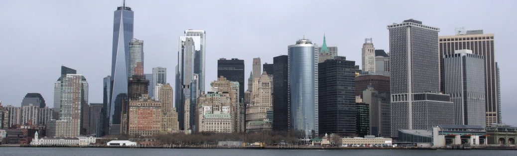
2023 war ich für ein Jahre in den USA. Jetzt ist es Trumpistan.
Bleibt fern. Besucht lieber Kanada und Mexiko. — And: Don’t buy American.
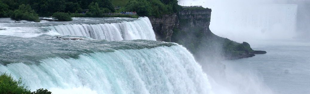
Meine Anfahrt erfolgt über den Niagara Scenic Parkway. Links ist der Niagara River1. Auf anderen Seite ist Kanada. Ich kann noch nicht ganz glauben, dass der Fluss nur ein paar Kilometermetern entfernt über die Niagarafälle 57 m in die Tiefe stürzt. Ich muss kurz realisieren, was ich hier mache: Ich bin in den USA. Das da drüben ist Kanada. Vor mir sind die Niagarafälle. Alles kenne ich nur aus Film und Fernsehen. Ach ja, ich bin zurück in New York. Es klingt verwirrend aber Buffalo und die US-Seite der Niagara Falls sind im US-Bundesstaat New York. Ich parke den Wagen am Fluss etwa 500m vor den Fällen. Der Niagara River teilt sich hier. Die meisten Wassermassen fließen westlich von Goat Island über den berühmten Horseshoe Falls. Ein kleinerer Teil geht nordöstlich der Insel über die Americal Falls. Und obwohl dies hier der Nebenarm ist, die Strömung ist der Wahnsinn. Ja, jetzt sieht man der Strömung, dass gleich was passieren wird. Kein Vergleich zu den ruhigen Bildern ein paar hundert Meter zuvor. Und es sind noch etwa 600 m bis zu den Fällen. Ich laufe am Park entlang (Google markiert hier American Rapids Viewing Area). Ja, kommt hin. Ein Brücke führt rüber auf Green Island. Die Gewässer rechts heißen Hells Half Acre. Ziemlich passen. Wer hier ins Wasser fällt, hat keine Chance auf Rettung. Ich wandere langsam rüber zu Goat Island und zu den American Falls. Es gibt eine Aussichtsplattform auf der kleinen Luna Island, die mitten in Hells Half Acre liegt. Auf der einen Seite sind die American Falls, auf der anderen Seite die schmalen Bridal Veil Falls.2
Wow. Impressive. Und das hier sind die kleinen Wasserfälle. Hier auf der insel gibt es die Cave of the Winds. Es ist ein Bereich unterhalb der Fälle, wo die Wassermassen nach ihrem Sturz in die Tiefe aufschlagen. Für Fotos nicht der beste Ort; für die Kamera weniger. Es ist eine Menge Gischt in der Luft. Ich kann es kaum erwarten, die Horseshoe Falls in Angriff zu nehmen. Aber zuvor kommt Regen. Eine Gewitterfront zieht auf. Ich befinde mich natürlich am blödesten Ort: weiter weg vom Auto kann ich nicht sein. Den Terrapin Point mit Blick auf die Horseshoe Falls lasse ich ausfallen. Ich habe keine Chance, trocken zu bleiben, trotzdem eile ich zurück zum Auto. Der Regen wird nach Internet mindestens eine Stunde dauern. Da kann ich in der Zeit auch im Hotel einchecken. Das Zimmer ist OK. Der Name Sheraton verspricht mehr, aber egal. Es war günstig. Der Parkplatz liegt direkt an der Niagara St, die zum Grenzübergang nach Kanada führt. Als Basiscamp optimal. Nach einer kurzen Pause Hotel geht es zurück zu den American Falls, genauer gesagt dem American Falls Tower. Ein Aussichtsturm. Hier führt auch ein Fahrstuhl hinab zu den Ausflugsbooten. Und trotz des Regenschauers ist hier eine riesige Warteschlange. Auf sowas habe ich nun wirklich keine Lust. Auf nach Kanada … Heute geht es über Cleveland nach Pittsburgh. Trotzdem. Ein paar Fotos von den Falls brauche ich noch. Und zurück am Tower sehe ich keine Warteschlage für die Bootsfahrt. Diese Chance muss ich nutzen! Rauf aufs Boot und los. Natürlich ist die Kamera nach der halben Tour hilflos. Das Objektiv ist nass, Wassertropfen auf der Linse. ich wechsel also wieder auf „Genießen ohne Beiwese“. Wir passieren die American Falls. Je näher wir den Horseshoe Falls kommen desto lauter wird, desto imposanter wird es. Die Hälfte der Fälle ist hinter der Gischt versteckt. Das Boot fährt in die Mitte des Halbkreises. Das Ticket hat sich gelohnt. Fast komplett rund herum um das Boot, in einer Entfernung von etwa 100m, stürzen Wassermassen 57m in die Tiefe, grob 2,5 Millionen Liter pro Sekunde! Theoretisch bin ich wieder in Kanada. Plastikverbrauch: Jeder Tourist bekommt einen Poncho aus Plastik. Das ist nicht verkehrt, da es sehr nass werden wird. Wenn ich jetzt aber hochrechne wie viele Touristen hier am Tag durchgeschleust werden und einen Poncho für 30 Minuten anziehen und danach wegwerfen …
I take the Niagara Scenic Parkway to get there. On the left is the Niagara River3. On the other side is Canada. I still can’t quite believe that just a few kilometers away, the river plunges 57 meters over Niagara Falls. I have to take a moment to realize what I’m doing here: I’m in the US. Over there is Canada. In front of me are Niagara Falls. I only know all of this from movies and television. Oh yes, I’m back in New York. It sounds confusing, but Buffalo and the US side of Niagara Falls are in the US state of New York. I park the car by the river about 500 meters before the falls. The Niagara River splits here. Most of the water flows west of Goat Island over the famous Horseshoe Falls. A smaller portion flows northeast of the island over the American Falls. And even though this is the tributary, the current is insane. Yes, now you can see from the current that something is about to happen. No comparison to the calm images a few hundred meters earlier. And it’s still about 600 meters to the falls. I walk along the park (Google marks this as American Rapids Viewing Area). Yes, that’s about right. A bridge leads over to Green Island. The waters on the right are called Hells Half Acre. Quite fitting. Anyone who falls into the water here has no chance of rescue. I slowly walk over to Goat Island and the American Falls. There is a viewing platform on the small Luna Island, which lies in the middle of Hells Half Acre. On one side are the American Falls, on the other side the narrow Bridal Veil Falls. 4
Wow. Impressive. And these are the small waterfalls. Here on the island is the Cave of the Winds. It is an area below the falls where the water hits the ground after its descent. Not the best place for photos; not so good for the camera. There is a lot of spray in the air. I can’t wait to tackle Horseshoe Falls. But first, rain. A thunderstorm front is approaching. Of course, I’m in the worst possible place: I couldn’t be further away from the car. I skip Terrapin Point with its view of Horseshoe Falls. I have no chance of staying dry, but I hurry back to the car anyway. According to the internet, the rain will last at least an hour. I might as well check into the hotel in the meantime. The room is OK. The Sheraton name promises more, but never mind. It was cheap. The parking lot is located directly on Niagara Street, which leads to the border crossing into Canada. Ideal as a base camp. After a short break at the hotel, we head back to the American Falls, or more precisely, the American Falls Tower. It’s an observation tower. There’s also an elevator that takes you down to the excursion boats. And despite the rain shower, there’s a huge line here. I really don’t feel like waiting in line. Off to Canada… Today we’re heading to Pittsburgh via Cleveland. Still, I need a few photos of the falls. And back at the tower, I don’t see any queue for the boat trip. I have to seize this opportunity! I hop on the boat and off we go. Of course, halfway through the tour, my camera is useless. The lens is wet, with water droplets on it. So I switch back to “enjoying without evidence.” We pass the American Falls. The closer we get to the Horseshoe Falls, the louder and more impressive it becomes. Half of the falls are hidden behind the spray. The boat sails into the middle of the semicircle. The ticket was worth it. Almost completely around the boat, at a distance of about 100 meters, masses of water plunge 57 meters into the depths, roughly 2.5 million liters per second! Theoretically, I am back in Canada. Plastic consumption: Every tourist gets a plastic poncho. That’s not a bad idea, as it’s going to get very wet. But if I extrapolate how many tourists pass through here every day, wear a poncho for 30 minutes and then throw it away… DEU


American Falls


Nachtrag vom 28.06.2023


ENG
American Falls
Addendum dated 28 June 2023